This post may contain affiliate links. If you make a purchase by clicking on these links, I may earn a small commission at no extra cost to you. Read the disclaimer for more information.
Standing on the most eastern tip of the Australian mainland, is the Cape Byron Lighthouse. From the popular tourist town of Byron Bay, the rocky peninsula of Cape Byron extends out into the Pacific Ocean. One of the best ways to explore this beautiful area is to walk the 3km Cape Byron Lighthouse trail that runs from town and along the spectacular coastline to the lighthouse.

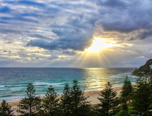
View of main beach in Byron Bay

Walking along the boardwalk near the start of the walking path
The Cape Byron Lighthouse Walk
The path follows the lighthouse road from the main beach, before turning off and heading along the rocky coastline to Watego’s Beach.

Watego’s Beach

View of the lighthouse from Watego’s Beach
At the other end of the beach, the path then enters into the National Park, climbing up and around the steep rocky side of the peninsula, before heading back down to give access to Little Watego’s Beach and the very tip of Cape Byron.

View of the coastline at Watego’s Beach as we climb up the peninsula

The rocky coastline at Cape Byron

The pathway leading to the viewing area at Cape Byron

Looking away from Cape Byron towards the lighthouse and most easterly point of Australia to the left

Little Watego’s Beach

The tip of Cape Byron
From here, you have to climb up a series of steps to get to the top of the headland where the lighthouse is located. There are amazing views of Cape Byron, the lighthouse and the coastline as you climb up and get to the top of the steps, and this is where you will be standing at the most Easterly point of Australia’s mainland.

View towards Cape Byron as I climb up the steps

View of Cape Byron from the top of the steps

The Cape Byron Lighthouse
It is now only a short walk along a flat path before climbing the final set of steps to the lighthouse itself.
Cape Byron Lighthouse
The Cape Byron Lighthouse has been alerting ships to the dangerous coastline since 1901, and it is now the most popular attraction in Byron Bay.

The steps leading up to the lighthouse

The Cape Byron Lighthouse


Looking up at the Cape Byron Lighthouse – built in 1901

Binoculars at the Cape Byron Lighthouse, with Byron Bay township in the distance to the left

The cliff drops nearly 100m below the lighthouse
If you’re travelling to Byron Bay, Australia, definitely take the time to do the Cape Byron Lighthouse Walk. It’s a great way to spend a morning or afternoon and experience the true beauty of the area.
Practical Information for the Cape Byron Lighthouse Walk
*Updated 2025
The Cape Byron Lighthouse Walk is also known as the Walgun Cape Byron Walking Track which is a scenic 3.7 km loop.
Trail Overview:
Distance: 3.7 km loop
Time: Approximately 1 to 3 hours, depending on pace and stops
Difficulty: Suitable for most ages and fitness levels. The trail is well marked but there are a lot of steps. The trail can be shortened by starting at Watego’s beach.
Terrain: The trail includes short steep hills, steps, and uneven surfaces.
Access Points: The track can be started at various points, including Captain Cook Lookout, The Pass, Wategos Beach, and directly at the Cape Byron Lighthouse.
Facilities: Parking is available at multiple locations, but it can be limited during peak times. Restrooms and a café are located near the lighthouse. There are also toilets at Watego’s Beach.
Hi Dean lovely post. I am in South Africa Cape Town and am far away form Cape Byron. But we have a lot in common. We have a lot of light houses. And beautiful nature like yours. I like the way you created your post with lots of great photos. As bloggers we can can use a lot more images like you did.
I am writing a post on all the light houses around Cape Town using Google Maps to map them. But the idea is that only people who join my newsletter will get access to the map. These can be done via a day trip in one day.
Do you guys have more Light Houses in this area or are they far apart?
Hi Johan. Cape town is a city I would really love to visit, and in fact, all of South Africa! It looks beautiful there.
There aren’t any other lighthouses in this particular area as the coast certainly isn’t as dangerous as it is around Cape Town 🙂
It will be great to have you visit our country. Have a lot of blogging fun.
Beautiful photos! I am definitely jealous that you’re in such a beautiful place
Thanks Brock. I am definitely lucky to live in this area! Cheers
what an absolutely stunning coastline. LOVE that first shot! =D
– Maria Alexandra
Hey Maria. It is a very spectacular coastline with a lot of beautiful features. Glad you liked the photos. Cheers!
Byron Bay has to be one of the most beautiful spots in the world (I’m not biased at all!). Stunning photos 🙂
I’d have to say that I definitely agree with you Lauren. It will always be one of my favourite spots 🙂 Cheers
This looks like a beautiful walk! What a unique looking lighthouse.
Hey Ellen. It is a very beautiful walk. The coastline is stunning, and the lighthouse at the end is the big reward 🙂
[…] Beach in Byron Bay, Australia. I took this photo while walking the beautiful 3km trail to the Cape Byron Lighthouse. If you want to get away from the crowded main beach in Byron Bay, Watego’s Beach is only a […]
wow! What a great walk. I love taking an afternoon stroll along the coast and this one looks like one of the top coastal walks out there. Thanks for showing us some great scenery in your beautiful photographs.
I’m glad you liked the photos Deb. This is a very beautiful walk. There’s not much better than a nice stroll along some beautiful coastline 🙂
[…] top beach and surf spots, plus a true backpacker haven. I took this photo while beginning the walk to the Lighthouse at Cape Byron – the most easterly point of the Australian mainland. This is a lovely walk and a must do […]
[…] Bay has some of the top-notch beaches in Australia. Byron Bay is easily accessible from the Gold Coast and several destinations along the coast of New South […]